+7 (812) 328 9282 - Office, +7 (812) 328 9248 - Museum info@karpinskyinstitute.ru
Russian Geological Research Institute (VSEGEI)
Russia is the largest country in the world. Its total area with adjacent waters is about 23 million km2, which is equivalent to approximately 11% of the Earth's total land area. The major systematic study of the country is geological mapping at 1:1,000,000 scale with the compilation of sets of state geological maps.
The first generation of such maps was compiled in the 40-60s of the last century for the entire area of the USSR. In the 80-90s, a new series of maps of the second generation was prepared. These were the regular paper geological maps, accompanied by explanatory notes with the geological description of the area.
At the end of the 90s, a new concept of geological mapping was defined, and already in 2002, the Program for the compilation of the third generation of the State Geological Maps-1000 was launched, which will be fully completed by 2025.
Distinctive features of the maps of the third generation are:
- compilation of sets of the State Geological Maps in digital form with accompanying databases;
- mapping not only the land area of the Russian Federation, but also the adjacent waters of the Arctic seas and the Arctic Ocean;
- mass introduction of isotope-geochemical and geochronological studies;
- field work in reference areas, as well as a significant expansion of completeness.
With the advent of new mapping and digitalization technologies, further updating of the state geological maps at 1:1,000,000 scale in the form of separate sets with a periodicity of 20-30 years has become completely irrational and not in demand. Thus, relatively recently the question arose about the development of the State Geological Map at 1:1,000,000 scale as a unified geological mapping model of the country and adjacent water areas, with the possibility of constant modernization and updating of maps using new data in monitoring mode.
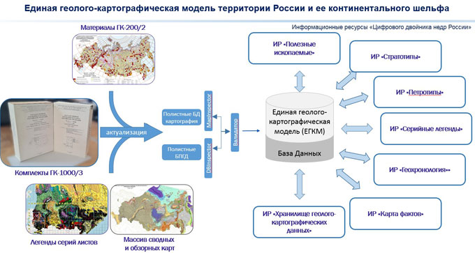
Therefore, in 2020, a concept was developed and the first State Geological Map-1000 Monitoring was launched. The concept provides for a significant expansion of the information capacity of the sets through integration with various information resources of both the “Digital Twin of the Mineral Resources of Russia” and Rosgeolfond, as well as the possibility of remote presenting of information both online and by downloading individual sets at the user’s request.
The substantive basis of the Monitoring is an array of the State Geological Map-1000/3 sets prepared over 20 years, updated to the modern level by groups of sheets. However, the background technology had to be developed almost from scratch. As a result, the Information Technology Centre of the Karpinsky Institute has developed a unified geological mapping model of Russia and its continental shelf at 1:1,000,000 scale (UGMM) on a scalable software platform that provides integration, processing, maintenance, and presentation of digital geological information.
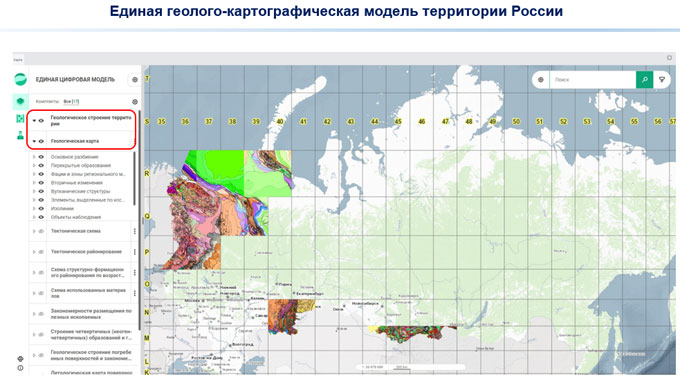
This innovative technological system enables to view the maps in the set both individually and in a combined mode, while you can combine both individual layers of different maps and various information resources, for example, the resources of the Karpinsky Institute: Mineral Resources, Serial Legends, Map of Factual Material etc.
UGMM enables to automatically generate symbols based on digital models and the digital Symbol Database developed at the Karpinsky Institute, and show all the marginal representation (sections, correlation charts, classification tetrahedrons, etc.). The system forms a connection between targets in the map, in symbols and in the text of the explanatory note, which is actually equivalent to the digital State Geological Map in interactive mode.
At the moment, 94 sets (126 numbered sheets) of the State Geological Maps-1000 are available. Sheets are entered into Monitoring in groups. The preparation is conducted in three stages and consists of updating and linking maps, as well as loading them into the UGMM. In 2024, the preparation is carried out within Taimyr and Norilsk, the Aldan-Transbaikal region, the west and south of the European part of Russia, Verkhoyansk, Chukotka and northern Kamchatka, as well as the Laptev Sea shelf. The main stage of monitoring, when new information is accumulated and integrated into the State Geological Map-1000 sets loaded into the UGMM, is carried out in the North-West, the south of the Urals, and Altai.
Over the next 10 years until 2035, it is planned to completely load all sheets of the State Geological Map-1000 into the UGMM and move on to the main stage of monitoring. New information will be obtained both from various sources (new data from the State Geological Map-200/2, scientific research materials of the Russian Academy of Sciences, materials of mineral managers, publications and international projects of the Karpinsky Institute), and when the Karpinsky Institute conducts its own field work, accompanied by the up-to-date laboratory and analytical research. UGMM technologies also continue to develop, expand, and integrate into all resources of the Karpinsky Institute and the Federal Agency for Mineral Resources.
All information accumulated during monitoring and integrated into the UGMM is BigData, large-volume structured data arrays. Using neural networks or artificial intelligence, this data can be used to identify promising areas to predict mineral deposits, as well as 3D modelling of underground spaces with the construction of 3D geological models.