+7 (812) 328 9282 - Office, +7 (812) 328 9248 - Museum info@karpinskyinstitute.ru
Russian Geological Research Institute (VSEGEI)
The General Meeting of RAS members was held at the Russian Academy of Sciences on June 23, 2020. For the first time, the meeting was held online due to restrictive measures in the Russian Federation aimed at counteracting the spread of the new coronavirus infection COVID-19. More than 2,000 people were invited to attend the meeting remotely — academics, corresponding members, professors of the Russian Academy of Sciences, and guests.
During the meeting, Academician Aleksandr Sergeev, the President of the Russian Academy of Sciences, presented an annual report on the most important scientific achievements of Russian scientists in 2019 and the implementation of the state scientific and technical policy in Russia. In the field of "Earth Sciences", A.M. Sergeev mentioned eight major achievements, among which, as a primary achievement, he noted the 1:2.5 M Map of Quaternary Formations of the Russian Federation and Adjacent Deep Water Areas (Editors-in-chief: O.V. Petrov, A.F. Morozov, A.S. Zastrozhnov (responsible editor), V.K. Shkatova, E.A. Minina, V.D. Tarnogradsky, V.I. Astakhov, V.M. Ryzhkova, M.A. Chuiko, S.B. Yakovleva, O.Yu. Zhuravleva, L.E. Pestova, O.N. Snezhko (VSEGEI); E.A. Gusev (VNIIOkeangeologia); A.A. Sheiko (Yuzhmorgeologia)).
The work was performed at VSEGEI as part of the state assignment of the Federal Agency on Mineral Resources and includes results of state geological mapping at a scale of 1: 1,000,000 of the third generation and the latest scientific data of the Russian Academy of Sciences.
The Map of Quaternary Formations of the Russian Federation is the latest scientific summary on the structure of the Quaternary cover of Russia. The map is based on the detailed General Quaternary Stratigraphic Scale, in which the steps of all parts of the Neopleistocene are correlated with the stages of the oxygen-isotope scale.
The map is accompanied by 1:25 M inset maps of structural zoning; zoning based on Quaternary stratotype regions; distribution of permafrost and seasonal frozen rocks; marine transgressions and glaciations; and the interregional Quaternary stratigraphic map of the Russian Federation.
The Explanatory Note to the Map outlines principles of constructing the legend, the genetic classification of sediments, correlations of regional stratigraphic units of Quaternary sediments of the country with taxa of the general scale, geographical and paleogeographic zonality in the distribution of various genotypes. Structural features of the Quaternary cover of large regions of Russia are given, and problems of Quaternary paleogeography in Russia, including debating points, are highlighted.
In 2019, the map was presented at the INQUA Congress, Ireland, Dublin, where it received a high appraisal from its participants and was a worthy VSEGEI contribution to the unique tradition of general mapping in Russia.
In addition to the Quaternary Map, the main achievements are as follows:
- Studying the 3D seismic structure of the crust under of Avacha group volcanoes in Kamchatka (Institute of Petroleum and Gas Geology and Geophysics, Siberian Branch, Russian Academy of Sciences; Institute of Volcanology and Seismology, Far Eastern Branch, Russian Academy of Sciences)
- System for predictive assessment of rock condition during development of mineral deposits (Mining Institute, Kola Scientific Center, Russian Academy of Sciences)
- Reconstruction of the atmospheric circulation in the North Atlantic over the past 40 years (P.P. Shirshov Institute of Oceanology, Russian Academy of Sciences)
- Studying the influence of the glaciers’ disintegration in North America and the Kamchatka Peninsula on the hydrology of surface waters in the northern part of the Pacific Ocean and climate (V.I. Il'ichev Pacific Oceanological Institute, Far Eastern Branch, Russian Academy of Sciences)
- Empirical climate modeling of the past: Reconstruction of the climate change mechanism in the Middle Pleistocene (Institute of Applied Physics, Russian Academy of Sciences)
- Monitoring of the cryolithozone temperature showing the rate of permafrost degradation (Permafrost Institute, Siberian Brunch, Russian Academy of Sciences; Institute of Earth Cryosphere, Siberian Brunch, Russian Academy of Sciences; Tyumen State University; Institute of Environmental Geoscience, Russian Academy of Sciences; Pushchino Scientific Center, Russian Academy of Sciences; Komi Scientific Center, Russian Academy of Sciences)
- Control of underwater nuclear and radiation hazardous objects and ecosystem parameters (P.P. Shirshov Institute of Oceanology, Russian Academy of Sciences).
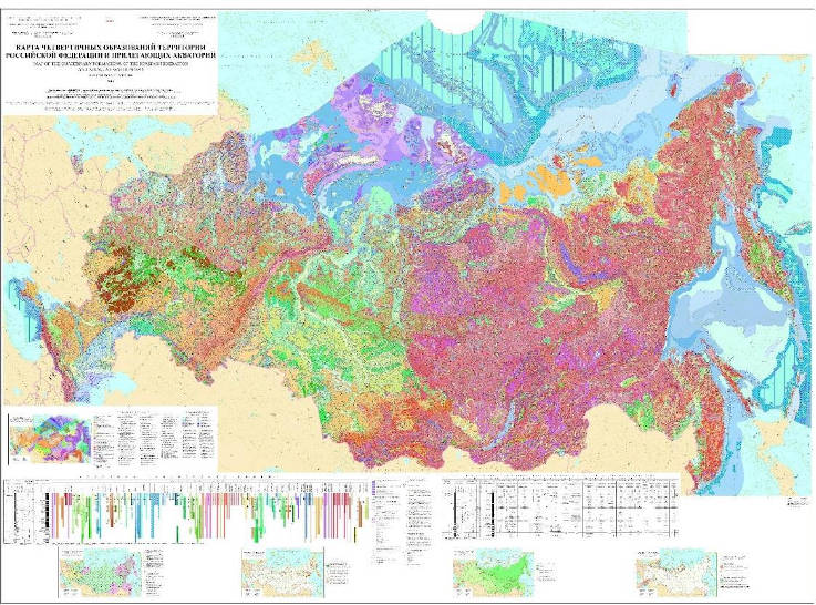
1:2.5 M Map of Quaternary Formations of the Russian Federation and Adjacent Deep Water Areas

