+7 (812) 328 9282 - Office, +7 (812) 328 9248 - Museum info@karpinskyinstitute.ru
Russian Geological Research Institute (VSEGEI)
2000 – organization, holding and participation in events dedicated to the 300th anniversary of the mining and geological survey of Russia: the All-Russian Congress of Geologists, the scientific-practical conference "Geological Survey and Mineral Resources of Russia on the threshold of the 21st century", and the international exhibition "Exploration-2000".
Congress began with the announcement of the greeting from the President of the Russian Federation V.V. Putin and the Government of the Russian Federation. Among the presentations at the plenary session of the congress and conference, we note those by A.I. Krivtsov (TsNIGRI) “Global Mineral Resources Supply in the 21st Century. Quantitative Estimates”, A.F. Morozov (Ministry of Natural Resources of the Russian Federation) “Three Centuries of Geological Mapping in Russia”, and O.V. Petrov, V.K. Putintsev, V.M. Terentyev, A.I. Burde "Role of GeolCom-VSEGEI in the Geological Study of Russia".
Large summarizing cartographic and monographic works were completed. Among them are the Geological Map of Russia and the Adjacent Water Areas at 1:2,500,000 scale (Editor-in-chief B.A. Yatskevich, Deputy editor-in-chief O.V. Petrov, V.K. Putintsev, Responsible editor S.I. Strelnikov, E.M. Zablotsky), compiled based on the synthesis of extensive geological material accumulated over almost a 20-year period after the publication in 1982 of the geological map of the USSR at the same scale edited by Academician D.V. Nalivkin; Geological and Mineragenic Map of the World at 1:15,000,000 scale (Editor-in-chief L.I. Krasny), Map of Magnetic Anomaly Field (ΔТа) of Russia and Neighbouring States (within the borders of the former USSR) at 1:5,000,000 scale (Editor-in-chief T.P. Litvinova).
At the ХХХI IGC Session (Rio de Janeiro), in addition to the above, the latest Geological Map of the World, including the bottom of the World Ocean (Editor-in-chief B.A. Yatskevich, Responsible editor S.I. Strelnikov, O.P. Dundo), Metallogenic Map of Russia at 1:5,000,000 scale (Editor-in-chief A.D. Shcheglov), and Map of the Quaternary Formations of Russia at 1:5,000,000 scale (Editor-in-chief I.I. Krasnov, edited by B.A. Borisov, E.M. Minina) were presented.
Monographs “Three Centuries of Geological Mapping in Russia” (edited by A.I. Burde, N.V. Mezhelovsky, A.F. Morozov), “Platinum Mineralization of the Black Shale Type and Criteria for its Prediction” by L.I. Gurskaya, “Salt Sedimentary Basins” by G.A. Belenitskaya etc. were published.
Historical building of the Geological Committee on the Sredny Prospect of Vasilievsky Island, which was named by Academician F.N. Chernyshov “the Palace of Geology”, an outstanding monument of architecture and history, was restored. In brilliant St. Petersburg, few buildings can be compared with strict and solemn monumentality, preservation of the facades and originality of the glazed roof (for natural lighting of minerals and rocks in the geological museum), an abundance of bright names and events in their biography.
2001 – According to the results of the competitions, the Ministry of Natural Resources of the Russian Federation assigned VSEGEI for 2001-2005 the functions of the leading institution to carry out geological study and assessment of mineral resources of the Russian Federation and its continental shelf.
Compilation of sets of sheets of the State Geological Map of the USSR, then the Russian Federation at 1:1,000,000 scale (new series) was completed.
At VSEGEI, the Centre of Isotopic Research was created, the first laboratory-analytical complex in Russia capable of carrying out the entire spectrum of modern analytical isotope studies both on the topics of the Ministry of Natural Resources of the Russian Federation and other institutions.
Published: Map of Ore-Bearing Formations and Ore Zones of the East European Platform Cover at 1: 2,500,000 scale (Edited by Yu.G. Staritsky), Map of the Quaternary Formations of Russia at 1:5,000,000 scale (Editor-in-chief I.I. Krasnov, Edited by B.A. Borisov, E.A. Minin), Map of Ore Clusters of Russia at 1:5,000,000 scale, and the monograph "Ore Clusters of Russia" (edited by E.V. Plyushchev).
At the International Cartographic Congress in Beijing, the St. Petersburg Cartographic Factory of VSEGEI was awarded with Diplomas for excellent performance for the publication of geological maps (Geological Map of Russia and Adjacent Water Areas at 1: 2,500,000 scale and the Geological Map of the World at 1:15,000,000 scale).
2002 – Jubilee session of the Academic Council dedicated to the 120th anniversary of the Geological Committee – VSEGEI took place. Along with presentations on the Institute’s history – “Year 1882. World. Russia. Petersburg” (A.I. Zhamoida) and “Geological Committee – VSEGEI – 120 years” (O.V. Petrov, V.K. Putintsev, B.A. Borisov), it considered results of the Institute's work over the past year and outlined solutions to research programs for the future (A.F. Morozov (Ministry of Natural Resources of the Russian Federation), O.V. Petrov, E.A. Kiselev, V.V. Shatov, S.S. Shevchenko, Yu.M. Erinchek and others.
International activity of VSEGEI was further developed: the first international workshop was held with the participation of representatives from China and Russia on the quadripartite Sino-Russian-Kazakh-Mongolian project “Atlas of Geological and Geographical Maps of Central Asia and Adjacent Areas” at 1:2,500,000 scale and the work plan for 2003-2006 was approved; within the framework of the international Scandinavian project “Fennoscandian Metallogenic Map” (Finland, Russia, Sweden, Norway), the first meeting was held and prospects for the development of this project were determined; joint Russian-French work continued in the field of uranium geology and metallogeny (COGEMA, CREGU).
Volume 3 “Eastern Siberia” was published (edited by N.S. Malich, co-editors E.P. Mironyuk, E.V. Tuganova), which is part of the six-volume monograph “Geology and Mineral Resources of Russia”.
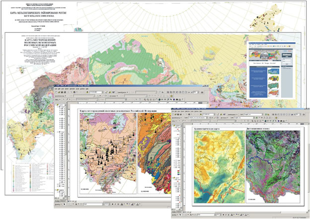
Work began on compilation of the GIS Atlas “Russia's Mineral Resources”, which includes geological, tectonic, metallogenic and gravity maps, map of magnetic anomaly field and energy resources, and a database of mineral deposits.
In the same year, work began on the compilation of sets of Gosgeolkarta-1000 of the third generation. It is important to note that Gosgeolkarta-1000 of the third generation differs from previous maps in that it is a GIS that includes digital mapping materials and databases that are closely integrated with the federal GIS-Atlas “Russia's Mineral Resources”. All this opens up the possibility of operational monitoring of data on the geology and mineralization of Russia, both at the informative and technological levels.
Active introduction of these new technologies cannot be regarded only as a formal response to the “trend of the times”. This is, first of all, the answer to modern requests of the state and mineral developers, from whose side the demand for cartographic products has recently increased several times.
2003 – Organizational, scientific, and production activities of VSEGEI were carried out in accordance with the priority areas of the Mineral and Raw Materials subprogramme of the Federal Target Program “Environment and Natural Resources of Russia (2002–2010)”, approved by the Government of the Russian Federation. The main efforts of the Institute staff were focused on solving the problems of preparing a general geological and forecast mineragenic basis for strengthening and expanding the mineral resource potential and ensuring the environmental and geological safety of the country.
Four GIS Atlases of geological maps at 1:1,000,000 - 1:2,500,000 scale were compiled with databases on the North-Western, Southern, Volga, and Far Eastern federal districts and constituent entities of the Federation; draft “Forecast Metallogenic Map of Russia” was prepared at 1:5,000,000 scale with the display of targets of global, trans-regional, and regional rank.
Compilation of the third generation of Gosgeolkarta at 1:1,000,000 scale was successfully continued on sheets covering the most significant geological and economic areas; a preliminary analysis of geophysical, geochemical, and remote sensing data was carried out, and promising sites were outlined for more detailed assessment.
Digital model of an integral map of deep tectonic zoning of the continental Russia at 1:5,000,000 scale, as well as a model of deep structure for the major mineragenic provinces of European Russia, Karelia-Kola and Voronezh, were created.
In collaboration with TsNIGRI, VIMS, VIEMS, IMGRE and other sectoral institutes, a large amount of work was carried out to revise the quantitative and geological and economic assessment of forecast resources with the formation of a data bank and the preparation of corresponding maps at 1:5,000,000 – 1:10,000,000 scale for Russia as a whole and certain regions (diamonds, precious and non-ferrous metals, uranium, hydrocarbons, nonmetallic and other minerals). With these works, VSEGEI essentially laid the foundations for the creation of a sectoral information system, GIAS “Russia's Mineral Resources”, on mineral resources with banks of GIS-linked data, systematically updated in a monitoring mode, on deposits, mineral occurrences, ore clusters, and other promising local mineragenic targets.
Scientific and technical cooperation with foreign countries actively developed. The following were held: the second workshop on the compilation of the Fennoscandian Metallogenic Map on the topic “Fennoscandian Ore Deposits Database”; the first working meeting of representatives of the Geological Surveys of the Arctic states (Russia, Finland, Sweden, Norway, the USA) on the topic “Arctic Geology and Minerals: Prospects for Joint Circumpolar Research”; the second Sino-Russian-Kazakh-Mongolian-Korean meeting on compiling the Atlas of Geological Maps of the Central Asia and Adjacent Areas; workshop on coastal monitoring and management of its natural resources (exemplified by St. Petersburg) (Russia, Denmark).
Out of print: “Outstanding Scientists of the Geological Committee – VSEGEI” (authors L.I. Krasny, A.I. Zhamoida, I.N. Kurek, G.N. Shaposhnikov); Metallogenic Dictionary (Editor-in-chief A.I. Krivtsov, deputy editor-in-chief O.V. Petrov, V.M. Terentiev) and others.
2004 – Compilation of GIS Atlases of geological maps at 1:1,000,000 - 1:2,500,000 scales with databases on the Central, Ural, and Siberian federal districts and constituent entities of the Federation was completed. The work is the result of joint efforts of VSEGEI and the leading exploration institutions and enterprises of the Central, Ural, and Siberian regions.
Creation and commissioning of a modern instrumental complex for geochronological and geochemical isotope methods, the Centre of Isotopic Research, which is the first laboratory and analytical complex in Russia capable of performing the entire spectrum of modern analytical isotope studies for the needs of geological study, assessment and localization of mineral resources and environmental monitoring, was successfully completed. A unique Centre for the reception and processing of remote sensing data was created, the task of which is to ensure the full technological cycle of the use of Earth remote sensing data, from obtaining space information to implementing the developed GIS processing technologies and integrated interpretation of images in the manufacturing enterprises of the Russian Ministry of Natural Resources.
Work developed under contracts with mining companies and other institutions.
2004 – is the year of the ХХХII International Geological Congress. VSEGEI and Cartographic Factory employees actively participated in the ХХХII IGC Session and the International Exhibition “GeoExpo-2004” in Florence (Italy), many of them made presentations and participated in the work of committees and commissions of IUGS and associated institutions.
Exhibition demonstrated digital materials published under the guidance of the Main Editorial Board for Geological Mapping: Geological Map of Russia at 1:2,500,000 scale, maps of magnetic anomaly and gravity field of Russia at 1:5,000,000 scale, draft tectonic and geological maps of the Ural-Mongolian belt at 1:2,500,000 scale compiled by the geological surveys of Russia, China, Kazakhstan, and Mongolia. Updated drafts of the map of mineral resources and fuel and energy resources of Russia at 1:5,000,000 scale and others were also presented. In continuous mode, two laser panels showed video and computer materials on GIAS Mineral Resources, State Geological Mapping of Russia, environment of the Gulf of Finland, TsNIGR Museum activities. Particular attention was attracted by a computer demonstration of the GIS atlas “Russia's Mineral Resources”, the latest information product of the Russian Ministry of Natural Resources.
2004 – The year turned out to be extremely fruitful in terms of intensifying the international activity of VSEGEI, and even a turning point in organizational sense. A new form of international cooperation was found, involving independent financing of work by each party on its area.
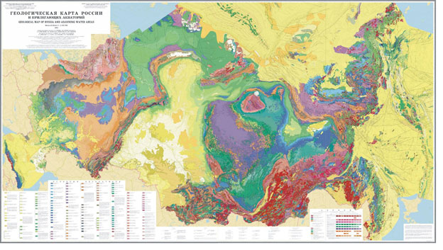
Geological map of Russia, 2004
This year, VSEGEI was developing the geological and economic research initiated by Rosnedra, aimed at modernizing the existing raw material base in the context of socio-economic, geopolitical, and logistic planning of government events, substantiating and identifying mineral resource centres for economic development.
Publishing activities of the year are represented by the following products: Atlas of the Mesozoic Marine Fauna of the Far East (authors I.I. Sey, T.M. Okuneva, T.D. Zonova, E.D. Kalacheva, E.A. Yazykova); volume "Tectonics and Geodynamics" of the encyclopaedia "Planet Earth" (edited by L.I. Krasny, O.V. Petrov, B.A. Blyuman); Izvestia VSEGEI. 2003. (Editor-in-chief O.V. Petrov); monograph "Evolution of the Early Precambrian Earth's crust" by E. B. Nalivkina.
In conclusion, it should be noted that created in VSEGEI in 2004 intellectual property, powerful information resources, high organizational and scientific potential, creation and commissioning of a modern instrumental complex of geochronological and geochemical isotope methods and a hardware-software complex for receiving Earth remote sensing data, as well as intensification of international cooperation is a guarantee of effective activities and relevance for the coming years.
GIS Atlas, 2004
2005 – Main efforts of the Institute's staff in the thematic aspect were focused on solving the problems of preparing scientific (general geological, forecast mineragenic, modern high-tech laboratory-analytical and Earth remote sensing) bases for strengthening and expanding the mineral resource complex and ensuring the country's environmental safety.
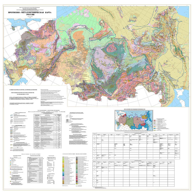
Forecast metallogenic map of Russia, 2005
FGUP “VSEGEI”, being the leading institution of the Federal Agency on Mineral Resources (Rosnedra) of the Ministry of Natural Resources of the Russian Federation in the field of regional geological study of the country and its scientific and methodological support, in 2005 took an active part in the implementation of the state order in terms of providing and direct fulfilment of regional geological, geological and geophysical, geosurveying, and deep geophysical investigations in Russia. The scope of exploration and survey for solid minerals and hydrocarbons increased significantly.
Work continued on a comprehensive geological and economic analysis of the Russian raw material base from the standpoint of the emerging global market environment.
Scientific and technical cooperation with foreign partners was active (China, France, Norway, Mongolia, Kazakhstan, Korea, USA, Canada, Finland, etc.).
Back in the 30s of the XX, speaking about the emerging trends in the development of science and productive forces, V.I. Vernadsky noted that “... the growth of scientific knowledge is quickly erasing the boundaries between individual sciences. We are increasingly specializing not in sciences, but in problems. This allows, on the one hand, to delve extremely deeply into the phenomenon under study, and on the other, to expand its coverage from all points of view” (Reflections of a Naturalist. M: Nauka. Book 1. 1975; Book 2. 1977).
As a result of a wide range of studies, both in terms of methods and geography, on the problems being handled, a number of important geological results were obtained in practical and scientific terms:
1. The joint work of VSEGEI and local enterprises identified and substantiated 24 (all along Rosnedra, about 50) promising metallogenic targets, for which the estimated resources of gold, diamonds, platinum, silver, polymetals and rare metals were evaluated. Among them, one can note the Pyatirechensk copper-precious metal ore cluster in the Northern Urals, Kuzeevo gold ore cluster, Mamakan-Yanguda gold-mercury zone, Vorogovo gold-ore placer region, Kokertai gold-ore cluster, Sarasa gold-mercury zone, Sugul-Biryulya manganese cluster; in the Far East, Kun-Manye zone of Pechenga-type copper-nickel ores, Malinovsky tungsten-bearing ore region.
Three of them (Pyatirechensk copper-noble metal ore cluster, Sarasa gold-mercury zone, Kun-Manye zone of copper-nickel ores) were transferred to the distributed subsurface reserves.
A significant role in these results belongs to the completed compilation of the first 20 sets of Gosgeolkarta-1000/3.
2. Results of deep regional geological and geophysical investigations supervised by VSEGEI made it possible to re-evaluate the prospects of metal potential in a number of geologically complex areas in the North-East, Central Siberia, and south of the European Platform. For example, new materials were obtained on the Batolit reference line in the Pre-Patom Regional Trough, which significantly expand the petroleum prospects of this structure. The 1-EB line in the Voronezh Massif substantiates new metallogenic zones of non-ferrous, ferrous, and noble metals.
3. Hydrogeological studies in the Volga-Khoper artesian basin, located in the densely populated European part of Russia, made it possible to reassess its resource potential, substantiate areas promising for identifying sources of underground potable water, prepare and substantiate a forecast of changes in groundwater quality in areas with an intense technogenic load.
4. The inventory of the primary geological information fund across Russia was completed. Technical and regulatory documents governing its storage and handling were developed.
5. A new geochemical method was developed for prospecting for deposits covered by thick loose sediments: the superfine fraction analysis (MASF); existing technologies for interpreting geochemical data were improved.
6. For the first time, a GIS was created across the entire territory of Russia, combining information on all types of mineral resources of the Quaternary formations, geohazards and ongoing global changes in the environment, with models and diagrams of geological evolution, and possible scenarios of global climate changes.
7. A reference manual on the zonal stratigraphy of the Phanerozoic in Russia was created and the third edition of the “Stratigraphic Code of Russia” was prepared, which are desktop manuals in the expert activity of the Scientific Editorial Board when assessing Gosgeolkarta-1000/3 and 200/2 legends and sheets.
8. Methodological recommendations were created on the use of modern isotope geochemical methods and information technologies in stratigraphic and palaeontological studies, which greatly expands the recognition of environmental parameters of the geological past and the evolution of the organic world, and a set of documents was developed for sections proposed as global boundary stratotype sections and points.
9. A number of reference and encyclopaedic reviews were prepared and published, including volume "Tectonics and Geodynamics" of the encyclopaedic reference book "Planet Earth", the first book of the first volume of the monograph "Geology and Mineral Resources of Russia".
10. Based on the work results, new copper-nickel, platinum-metal, gold-ore and diamond-bearing targets in Karelia were identified; gold manifestations associated with the Upper Proterozoic-Vendian terrigenous deposits, where gold is accumulated in ancient palaeoplacers, were first detected at the Windy Belt target.
In 2005, socially significant indicators of the implementation of geological work results were achieved. Demand for geological and mapping products increased by 62%.
Institute significantly increased the activity and effectiveness of its international cooperation. Cooperation at the level of geological surveys allows us to identify priority areas and develop common standards for the synthesis of geological data in new large-scale projects. A number of technical regulations was prepared that ensure the international unification of the presentation of mapping materials and databases adjacent to Russia. VSEGEI experts are actively involved in the international projects, exhibitions, and conferences that promote the scientific, methodological, technological developments, information and other VSEGEI services on the Russian and international markets.
In addition, in 2005, VSEGEI made a major contribution to the development of sectoral programs: “Medium-term general geological and special exploration for the regional study of mineral resources of the land, continental shelf of the Russian Federation, the Arctic and Antarctic for the period 2006-2008 and until 2010” and “Main directions for the development of general geological and special investigations for the regional study of mineral resources of the land, continental shelf of the Russian Federation, the Arctic and Antarctic for the period until 2020”. The first of these programs was successfully tested by the Academy of Sciences, the Advisory and Expert Council under the Minister of Natural Resources of Russia and laid the foundation for state budget projects until 2008.
A number of scientific and workshops were held:
- Eighteenth scientific readings in memory of Academician A.P. Karpinsky (January 26, 2005, St. Petersburg, VSEGEI).
- Workshop on the problems of compiling sets of the State Geological Maps of the Russian Federation, 1:1,000,000 (third generation) summed up the results of the first stage on compiling Gosgeolkarta-1000/3 and outlined the tasks for the future (April 5-8, 2005, St. Petersburg).
- Sixth Baltic Stratigraphic Conference (August 23-25, 2005), St. Petersburg, VSEGEI.
- Workshop “Status of creation of an all-Russian network of reference geological and geophysical lines, parametric and superdeep wells as of October 1, 2005 (with an assessment of the geological effectiveness of the work performed) and consideration of proposals for the direction of work for 2006 and the near future” (regular meeting of the Geological Section of the Scientific and Methodological Council of the Ministry of Natural Resources of the Russian Federation on Regional Geophysics, Parametric and Superdeep Drilling) (October 25-28, 2005, St. Petersburg, VSEGEI).
- Workshop on the implementation of the GIS Atlas in the local and regional mineral developing agencies of the Southern Federal District (November 14-18, 2005, St. Petersburg, VSEGEI).
- Sixth scientific readings in memory of Academician A.D. Shcheglov (December 28, 2005, St. Petersburg, VSEGEI).
International cooperation actively developed; a whole series of events were prepared and held in its framework:
- 9th St. Petersburg International Economic Forum, June 14-16, St. Petersburg, Tauride Palace;
- Meeting of heads of geological surveys of the CIS and foreign countries, devoted to the consideration of the status of work on international projects in the field of geological study of mineral resources and mineral management, St. Petersburg, VSEGEI, June 13; work of project working groups June 14-15;
- IX session of the Intergovernmental Council for the Exploration, Use, and Protection of Mineral Resources of the CIS countries, June 13-16, St. Petersburg, VSEGEI;
- XII International Exhibition "Mineral Resources of the CIS Countries", June 14-16, St. Petersburg, Mikhailovsky Manege.
- 1st workshop on the international project “GIS Atlas of Geological Maps of Russia, the CIS and neighbouring countries” (November 24-25, 2005, St. Petersburg, VSEGEI).
In conclusion, it should be noted that in 2005, as a result of strengthening the forecast mineragenic aspect in all general geological studies, conducting a wide set of studies, both in terms of methods and geography, a number of important geological results were obtained, socially significant indicators of geological results implementation were achieved, intellectual property and information resources were created, international cooperation actively developed.
2006 – In the first decade of the XXI century, VSEGEI, meeting the requirements of innovative development, on the basis of a modern laboratory service and, above all, the Centre of Isotopic Research, brought the geological and mineragenic studies of the Institute to a leading position, giving them a certain investment attractiveness and creating the prerequisites for the development of such new areas like “isotopic geochemistry” and “isotopic metallogeny”.
It provides a solution to new technological problems associated with the introduction of digital geological mapping and improvement of information and computer systems of various classes and purposes. Scientific (general geological, forecast mineragenic, geological economic) bases are developed for strengthening and innovative development of the mineral resource complex and ensuring the economic and environmental geological safety of the country.
FGUP “VSEGEI”, being the leading institution of the Federal Agency on Mineral Resources (Rosnedra) of the Ministry of Natural Resources of the Russian Federation in the field of regional geological study of the country and its scientific and methodological support, in 2006 took an active part in the implementation of the state order in terms of providing and direct fulfilment of regional geological and geophysical, geosurveying and deep geophysical investigations in Russia. Prospecting for solid minerals and forecasting for hydrocarbons continued. Scientific and technical cooperation with foreign partners was active (China, France, Norway, Germany, Mongolia, Kazakhstan, Korea, USA, Canada, Finland, etc.).
Due to a wide range of studies, both in terms of methods and geography, a number of important geological results were obtained:
In the area of integral and overview mapping, work was completed on the compilation of:
- Atlases of integral maps of Russia: “Space Image of Russia”, “Atlas of Russian Geophysical Maps”, “Atlas of Russian Geochemical Maps”;
- special-purpose maps, text and illustrative materials of the volume “Nature. Environment” of the National Atlas of Russia
- overview forecast metallogenic map of Russia and map of specialized metallogenic zoning of Russia at 1:5,000,000 scale with allocated metallogenic zones, ore regions, and clusters favourable for the formation of large and super-large ore deposits;
- a set of small-scale geological maps of the Ural-Mongolian fold belt.
Intermediate and final results of the recent work initiated integration of Russian geological information into the international system of digital geological information. Today, the Institute is implementing three international projects aimed at such integration.
Within the framework of one of them, Geological, Tectonic, and Mineragenic maps at 1: 2 500,000 scale of the Russian Arctic, a set of geological and geophysical digital maps (magnetic anomaly field map, gravity map) and a GIS system for geology and mineralization of the Arctic areas were compiled.
In the area of small-scale mapping, 13 nomenclature sheets of Gosgeolkarta-1000/3 for the Central, Siberian, and Far Eastern regions of the Russian Federation were completed, more than 50 priority areas for setting up regional, forecasting, prospecting, and evaluation work were substantiated. In the studied areas, the initial resource potential of priority mineral raw materials was significantly expanded. High forecast and exploration efficiency of the work, obtained during geological mapping at 1: 1,000,000 scale, was largely achieved by the efforts of the Institute staff who took part in field research and also provided scientific and methodological support of work:
- For the western Upper Yana region, for the first time, a forecast was given for unconventional gold-(arsenic)-sulphide type of mineralization with silver. As a result, the forecast potential of the area for gold and silver was increased several times. Two promising sites were located;
- In Transbaikalia, polychronous gold ore manifestations of the “Elkon” type in the Mesozoic gumbaites and of the “Kuranakh” type in the zones of their hypergenic transformation were first identified and evaluated; uranium manifestations of the “unconformity” type were identified and evaluated, ore zones with complex uranium-gold-rare-metal mineralization in the Riphean conglomerates were identified. 13 promising areas for gold, platinoids, uranium, rare metals were localized;
- Allocation of the Barkovsky-Zhdanovsky potential copper-platinum-gold-bearing region in Taimyr was substantiated;
- For the Volga region, a 3D model of the geological environment was first developed with reference to scale 1: 1,000,000, which significantly increases the reliability of identifying the geological structure features, predicting saline and petroleum structures in platform areas.
In the area of regional geoenvironmental studies and preservation of geological monuments of Russia, an extensive search and examination of potentially dangerous underwater targets in the shallow waters of the Baltic Sea, as well as identification of flooded targets in the urban areas of the Neva River basin (the Fontanka, Zhdanovka, Smolenka, Karpovka, Okhta, Lesser Neva and others) were carried out. A set of studies was carried out to preserve the Palaeolithic painting of the Shulgan-Tash (Kapova) cave and its museumification.
In the area of regional scientific and methodological support for forecasting and prospecting works and assessing the resource potential of the areas, the following were completed:
- Forecast of ore clusters, regions, and ore-bearing zones with expected especially large deposits of strategic solid minerals;
- Assessment of the prospects for integrated industrial ore content in zones of ancient structural-stratigraphic unconformities and long-lived tectonic-fluidic zones in the eastern part of the Anabar shield; boulder prospecting for rich copper-nickel ores in the Allarechensk area of the Baltic Shield, etc.
In the area of thematic and scientific research, one of the main results of the past year is the completion of the program document "Main directions for the development of general geological and special investigations for the regional study of mineral resources of the land, continental shelf of the Russian Federation, the Arctic and Antarctic for the period until 2020" and approval by order of the Minister of Natural Resources of the Russian Federation.
In addition, in 2006, the Institute developed and put into practice more than 15 titles of methodological documents and software and technology modules aimed at improving geological survey, information and laboratory and analytical work; the 2nd edition of the Petrographic Code was prepared, a methodological manual “Fundamentals of Forecasting Technology of Large and Unique Ore Deposits” was compiled, etc.
In the field of laboratory and analytical work support: according to the results of international programs for comparing the analysis results (“proficiency testing”), VSEGEI Central Laboratory entered the top ten best laboratories participating in the Programs, and it turned out to be among the top five laboratories for determining gold, platinum, and palladium contents in test samples at the clarke level.
Isotopic characteristics of intrusive massifs, key accessory and rock-forming minerals were studied in the Norilsk region. Precision geochronological dating of various horizons in key intrusions was carried out. It seems that the ideas of the multi-chamber continuous formation of large stratified intrusions have found confirmation; large-scale processes of remobilization of crustal components, their role in the formation of ore deposits are shown.
High quality of the CIR work and the uniqueness of its capabilities led to the expansion of international cooperation and helps to increase VSEGEI authority in international projects. A number of technical regulations were prepared that ensure the international unification of the presentation of cartographic materials and databases for areas adjacent to Russia.
VSEGEI experts are actively involved in the international projects, exhibitions, and conferences that promote the scientific, methodological, technological developments, information and other VSEGEI services on the Russian and international markets.
Participation of the Federal Agency on Mineral Resources and the Institute in major international exhibitions and conferences was organized and supported, in particular: St. Petersburg International Economic Forum; PDAC (Canada); Session of the Intergovernmental Council for the Exploration, Use, and Protection of Mineral Resources of the CIS Countries; International conference in the framework of the Year of Russia in China.
In conclusion, it should be noted that in 2006, as a result of a wide range of studies, a number of important geological results were obtained, new intellectual property and information resources were created, the high quality of the CIR research and the uniqueness of its capabilities were noted, international cooperation actively developed.
The Institute meets its 125th anniversary on January 31, 2007 with a steady increase in the volume of work and an advance in the importance of geological research.
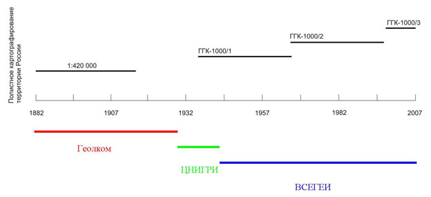
Time scale of gridded geological mapping of Russia, the USSR, and the Russian Federation (1882–2007)
2007 – Jubilee celebrations on the occasion of the 125th GEOLCOM-TsNIGRI-VSEGEI anniversary were solemnly held.
Scientific conference “125th Anniversary of the Geological Committee of Russia”, held in the form of an anniversary meeting of the Academic Council of VSEGEI on January 31, 2007 was dedicated to this significant event.
The main goal of the conference was to carry out a comprehensive analysis of the positive experience gained by the scientific schools of GeolCom-VSEGEI over 125 years in conducting geological surveys in Russia and other countries and to strengthen on this basis scientific and technical cooperation with national and foreign geological institutions and mineral developers.
The conference was attended by 350 people, including:
- 153 VSEGEI employees;
- 178 heads and representatives of 99 Russian institutions and enterprises;
- 19 heads and representatives of geological surveys and institutions from 10 foreign countries.
In accordance with the program of events, thematic tours to various Institute departments were organized. The conference participants were especially interested in visiting the Russian Geological Library (VGB), the TsNIGR Museum, the Centre of Isotopic Research (CIR), and the Remote Sensing Centre. VSEGEI guests got acquainted with the museum expositions and VGB book depositories, with the recent high-tech developments by CIR and Remote Sensing Centre employees.
Conference was opened with a presentation by the Chairman of the Academic Council, VSEGEI Director General O.V. Petrov “Scientific Schools of GeolCom-VSEGEI: Traditions and Trends in the Development of Geological Research”.
The speaker noted that GeolCom traditions are carefully preserved within the walls of A.P. Karpinsky Russian Geological Research Institute. They are represented by three main scientific schools:
- regional geology and geological mapping;
- metallogeny;
- palaeontology and stratigraphy.
Stability of the traditional GeolCom-VSEGEI scientific schools is determined by their healthy conservatism and the systemic nature of research, based on a detailed analysis of factual material.
“Despite the fact that the Institute functions have changed over the course of history, VSEGEI tasks, - stated O.V. Petrov, - remain the same as those of the Geological Committee: state geological mapping, provision of government bodies, mineral developers with geological data, and satisfaction of the general needs of society in basic geological information. The combination of many years of tradition and modern technology is for many decades the basis of effective VSEGEI work”. According to VSEGEI Director General, “the major feature of our Institute is the close connection of research and development with the solution of major practical problems”.
Speaking about the Institute features over the past 25 years, O.V. Petrov noted several major scientific and practical VSEGEI achievements. They are based primarily on the fact that already in the early 90s VSEGEI identified priority areas for creating a multifunctional geological mapping framework for solving the problems of strengthening the country's raw material base and rational mineral management. This includes: compilation of Gosgeolkarta (1:1,000,000 and 1: 200,000), geological maps for particular mining regions (1:50,000) using modern computer technology and developing models of their deep structure as a geological and geophysical basis for identifying formation and distribution patterns of mineral deposits.
During this period, VSEGEI’s links with the geological surveys from the near and far abroad continue to develop dynamically. Signing of a number of agreements and protocols at the intergovernmental level, as well as regular sessions of the Intergovernmental Council for the Exploration, Use, and Protection of Mineral Resources of the CIS countries and meetings of heads of geological surveys from foreign countries, significantly expanded the geography of joint international research, the range of urgent problems, and the improvement of technology and methods to solve these problems.
International cooperation urgently required modern work using GIS Atlases of geological maps. VSEGEI is completing the GIS Atlas “Russia's Mineral Resources”, which provides the user with system-wide, multidisciplinary information on the geology and mineral resources of the country. The GIS Atlas of Russia aroused great interest of the CIS countries and served as the basis for the creation in 2005 of the project “GIS Atlas of Geological Maps of Russia, the CIS Countries and Adjacent States” (scale 1: 2,500,000), which should be completed in 2008. The project involves Russia (coordinator), Ukraine, Belarus, Moldova, Georgia, Armenia, Azerbaijan, Kazakhstan, Kyrgyzstan, Uzbekistan, Tajikistan, and Turkmenistan.
Project “Atlas of Geological Maps of Central Asia and Adjacent Areas (scale 1: 2,500,000)” was also successfully implemented. The geological surveys of Russia, China, Kazakhstan, Mongolia, and South Korea took part in this work. Under a single GIS project, geological, tectonic and mineralogical maps were compiled, as well as the map of energy resources.
Digital maps were accompanied by an integrated database of coal, oil, gas, and solid mineral deposits. It is supposed to continue these works and, in particular, to implement a new international project to create a GIS Atlas of geological maps for the entire Asian continent. The project will require comprehensive studies in various fields of modern geology and geophysics, primarily this concerns deep tectonics, various types of geophysical and geochemical studies of the composition of mineral formations as indicators of crustal and mantle sources of matter. For the first time, the main metallogenic zones and ore-bearing structures in the Central Asian mobile belt, including typical ore targets, will be crossed by extended isotope geochemical transects.
Based on the “basin analysis” principles, the Institute implements large-scale projects in the Arctic regions and the West Siberian Plate, while specialized mineragenic, lithological-facies, and palaeogeographic maps, maps of the main hydrocarbon deposits and coal basins are being compiled.
Under the project “Atlas of Geological Maps of the Circumpolar Arctic, scale 1:5,000,000 (2005–2008) participated by the geological surveys of Russia, Germany, Canada, Norway, the USA, Finland and Sweden, it is planned not only to continue generalization of the tremendous amount of factual material obtained when compiling geological maps of a new generation at 1:1,000,000 scale, and case studies of the Russian Arctic seas, but also to link it with new geological data submitted by the circumpolar states.
Together with Finland, Germany, and Poland, VSEGEI also participates in the important international project, “Modern Resource Potential and Geological Hazards Assessment in the Baltic Sea and Its Coastal Zone”.
VSEGEI, - says O.V. Petrov, - actively develops another direction traditional for GeolCom-VSEGEI, represented by metallogenic scientific school, the notable achievements of which allow the Institute to participate in both Russian and international projects. One of them, carried out jointly with Finland, Norway, and Sweden, is the specialized international metallogenic project Fennoscandian Ore Deposit Database (2003-2008). It is important to note growing integration of VSEGEI metallogenic studies and other areas of geological research, an increase in the volume of “equipping” metallogenic studies with new technologies. Creation of VSEGEI analytical and isotopic centres can be considered an event that largely determined the formation of new trends and opportunities for metallogenic research.
Keeping the traditions of the scientific school of stratigraphy and palaeontology, VSEGEI is developing conceptually new areas of research: event stratigraphy, which actively involves in the analysis of regional and global rearrangements not only biostratigraphic, but also sequence-stratigraphic, cyclostratigraphic and palaeomagnetic data, as well as facies and palaeobiographic analysis results. Palaeontological-stratigraphic studies of GeolCom – VSEGEI are closely related to the activities of the Russian Palaeontological Society and the Interdepartmental Stratigraphic Committee. Russian Palaeontological Society, formed on the basis of GeolCom – VSEGEI, actively operates under the guidance of RAS Academician B.S. Sokolov and celebrated its 90th anniversary this year.
Interdepartmental Stratigraphic Committee, in recent decades headed by RAS Corresponding Member A.I. Zhamoida, still leads the creation and updating of regional stratigraphic charts of the Precambrian and Phanerozoic for various regions of the country.
VSEGEI developed a classification of geoheritage targets, suggested ranking them by scientific importance, compiled cadastres and geoheritage map of European Russia (scale 1:2,500,000, 300 targets, 1991), a geoheritage database for the entire country with map (scale 1:10,000,000, 400 targets, 1997).
It should be emphasized that the introduction of VSEGEI scientific achievements into the daily practice of geological work, production of scientific monographs, various maps and periodicals would be impossible without VSEGEI Publishing House and Cartographic Factory. Large contribution of the Cartographic Factory to the creation of map and book section at the exhibition during the XXVII IGC Session (1984, Moscow) was marked with a golden diploma of the Congress Organizing Committee. Overview maps published at the VSEGEI Cartographic Factory were awarded diplomas of the International Cartographic Congress (Sweden 1999, China 2001). The products of Russian geological cartography were adequately presented at the IGC sessions (Brazil 2000, Italy 2004). The informational and educational role of the Russian Geological Library (VGB) and TsNIGR Museum, which are the keepers of the traditions of VSEGEI scientific schools, is still important.
Official program provided speeches by 25 participants in the meeting.
All speakers noted the significant contribution of VSEGEI scientists to the “treasury of knowledge” of world geological science. Moreover, it was emphasized that throughout the history of this “forge of geological personnel” the theory was supported by tireless field geological practice. As a result, about three hundred of GeolCom-VSEGEI employees gave a scientifically-based forecast, discovered and first described more than 600 deposits in ore regions and provinces on four continents of the Earth.
Concluding the review of the measures taken, it should be noted that they contributed to the expansion and consolidation of cooperation with the regional departments of Rosnedra, Russian mineral developing companies, institutions of the Russian Academy of Sciences, and geological surveys of foreign countries.
For the anniversary of GeolCom-VSEGEI, two books were prepared and published summarizing the 125 years activities of GeolCom-VSEGEI: “125 years to the Geological Committee-VSEGEI” (Editors-in-chief O.V. Petrov, A.F. Morozov, Responsible editor B.A. Blyuman), “GeolCom-TsNIGRI-VSEGEI in Russian Geological Mapping. 1882-2007” (Editors-in-chief O. V. Petrov, A. F. Morozov, Responsible editor S.A. Toporets), and a brochure (in English) “From GeolCom to VSEGEI: Traditions and Development Trends” (Responsible editor B.A. Blyuman).
The jubilee publications are devoted to: the first, to the history of the Geological Committee, the first state geological institution in Russia, which, due to the continuity of scientific traditions, was inextricably linked with the history of the Russian Geological Research Institute (VSEGEI). In the jubilee collection, “the voices of the era” – authors and collective reports – present the 125-year history of GeolCom-VSEGEI; the second, to the establishment and development of a systematic geological study and mapping of our country from 1882 to 2007. Vivid examples show the continuity and consistency of the Russian geological mapping in GeolCom-TsNIGRI-VSEGEI for 125 years, the constant desire to increase social significance, economic efficiency of the created cartographic products under the motto “VSEGEI is a century-old tradition and recent technologies”.
In accordance with the list of directions, in 2007, the Institute carried out regional, geological and geophysical, geological surveying studies and creation of a state network of reference geological and geophysical lines, parametric and superdeep wells. The latter included both direct exploration work, and its scientific, methodological, and organizational support. This area is developing very dynamically and at a high technology level. Suffice it to say that in 2007, work in this focus area was carried out at 22 targets, and the “portfolio” of proposals for 2008 amounted to almost 40 targets. Workshops are held regularly to discuss the results and emerging issues on this topic.
In the area of regional geological research, the main institute efforts were focused on integral and overview regional geological generalizations, organizing and conducting small-scale geological mapping of Russia. At the same time, considerable efforts were directed at the scientific, methodological, and organizational support of the work. In the end, it should be noted that:
- monitoring of digital materials on the geological structure, mineral resources, the state and use of subsurface of the Russian Federation to solve the problems of mineral development at the federal and local levels was completed. The materials from the GIS Atlas of Russia are currently actively used for planning exploration work in almost all areas of Russia.
Measures for the development of this information system and its improvement are envisaged and are being implemented;
- continued work on integration into the international system of digital geological information in the framework of four projects to create integrated geological information resources and to develop cooperation with the CIS and neighbouring countries;
- A program was developed to create a geographically distributed automated system for collecting, storing, and using rock material collections;
- a fundamentally new product that enables to get an objective pattern of the state and prospects for the development of the raw material base in the Karelia-Kola region, to reveal the spatio-temporal relationships of minerals with geotectonic regimes, geological and ore formations, and also to identify the most promising areas for further exploration work, are compiled Metallogenic Map and Map of Deposits and Ore Occurrences in the Russian part of the Fennoscandian Shield at 1: 1,000,000 scale implemented as a GIS “Geology and Metallogeny of the Fennoscandian Shield”;
- Organized work, including field research, on 30 sheets of Gosgeolkarta-1000/3. The increase in geological exploration at 1: 1,000,000 scale amounted to 735 thousand km2. On three sheets, the work is currently being completed with good geological and predictive results, including metallogenic peculiarities of noble and polymetals in Taimyr, gold in the Verkhoyansk-Kolyma province. In total, according to operational data, in all sheets 9 promising targets were allocated for gold, platinum, alloying metals, non-metallic raw materials, which, in our opinion, represent a reserve of areas for the purposes of GDP-200 (3), forecast and prospecting works (4), prospecting works (2);
- maintaining compilation of Gosgeolkarta-1000 and other state budget targets of VSEGEI, the Centre of Isotopic Research reliably dated about 2,000 major intrusive, effusive, and metamorphic complexes, which led to a serious rethinking of the geological structure of entire regions. Such a scale of geochronological work was not in the entire history of Russian geology;
- for the first time based on integrated geoenvironmental work in the Neva River basin and the eastern part of the Gulf of Finland, a comprehensive assessment of the state of geological environment in the transition zone from land to water areas of various types was carried out.
Identified control and predicted geoenvironmental characteristics of the water areas bottom and coastal zones made it possible to establish natural and man-made geohazards.
The most important result of the work is the geological foundations of shore protection necessary for the implementation of the practical tasks set by the Government of St. Petersburg;
- A complete summary of new factual and cartographic material on the Baltic, Aldan, and Anabar shields, prospective for the discovery of unconformity-type deposits, based on which predicted uranium resources in P3 and P2 categories are substantiated and allocated. Predicted resource estimates were tested by the leading sectoral institute and can serve as the basis for planning rehabilitation of uranium raw material base;
- for all targets of regional geological works put into operation in the current year, a high-resolution remote base was prepared;
By order of Rosnedra, in September 2007, VSEGEI together with Sevmorgeo held an international scientific and practical seminar “Models of the Earth's Crust and Upper Mantle”, which was attended by more than 80 experts from 24 Russian institutions and foreign scientists from Australia, China, the Netherlands, Ukraine, Japan. The workshop enabled:
- to assess the current state of methods and results of studying the deep structure of the earth's crust and upper mantle;
- to discuss the main problems and priorities of deep studies;
- to outline the ways for further development of the deep studies methodology, data processing and interpretation;
- to note that Russian deep studies enjoy well-deserved recognition from the international geophysical community and meet the highest modern standards.
In recent years, VSEGEI has sharply intensified research in the field of exploratory geochemistry, in particular, in such a fundamentally important area as the development of effective technologies for the geochemical prospecting in typical landscape environments.
In this area, a new geochemical method was developed and patented in 2007 for the search for deposits covered by thick loose sediments: the superfine fraction analysis (MASF), which is an analogue of the Chinese highly efficient NAMEG method adapted to Russian conditions. Currently, this method is widely used by both government institutions and private companies in the Karelia-Kola region, the Far East, Siberia and the Urals, and is also being introduced in geochemical prospecting in Uzbekistan. In VSEGEI, MASF is applied directly at the PPR and POR targets, in particular, at Lesser Khingan site in the Jewish Autonomous Region, Prigranichny in the Primorsky Krai, Dugda in the Amur Region, Ozerny in the Urals.
Based on the results of these works, new promising areas were identified for setting up prospecting works; in three of which in the Jewish Autonomous Region and in Primorye prospecting for new sites will be carried out in 2008.
Central Laboratory made a significant contribution to the provision of data on the chemical and mineral composition of rocks, minerals, and ores for geological surveying, geochemical prospecting, exploratory, and environmental work carried out by FGUP VSEGEI under state contracts and agreements with outside institutions. In addition to production work, methodological research was carried out aimed at improving the quality of the applied analysis methods, and the introduction of new types of analytical work. In 2007, the laboratory took part in four international programs for comparing the results of analysis and certification of standard samples of rocks and ores, including the international standard sample of serpentinite composition – SW and, having confirmed the high quality of its analytical work, continues to be among the ten best laboratories participating in the programs, which, in turn, it provides high reliability of analytical support, and as a result, geological research of the Institute.
Work continued on a modern market assessment of the raw material potential of the Russian Federation and justification of the strategic directions for its expanded rehabilitation and innovative use based on new principles for its structuring and commercial zoning of the country.
Within the framework of international projects, fundamental geological surveys are being carried out in the Arctic, Karelia-Kola region, Central Asia, and the Caucasus. These studies were highly appreciated and served as the basis for proposals for the expansion of work, which gave an additional impetus to the dynamic development of VSEGEI international relations.
2008 – VSEGEI actively participated in the preparation and conduct of the XXXIII Session of the International Geological Congress and the International Exhibition GeoExpo-2008 (Oslo, Norway). Institute staff made presentations and took part in the work of IUGS committees and commissions, as well as associated institutions.
FGUP “VSEGEI”, the leading institution of the Federal Agency on Mineral Resources (Rosnedra) in the field of regional geological study of the country and its scientific and methodological support, in 2008, took an active part in the implementation of the state order in terms of providing and direct implementation of regional geological and geophysical, surveying and deep geoscientific work in Russia. Exploration for solid minerals, forecast of hydrocarbon raw materials continues. Meeting the requirements of the time, the Institute strengthens the forecast mineragenic aspect of all general geological studies, proceeds to 3D models of the deep structure for major mineragenic provinces, to quantitative assessment of resource potential of promising areas, expanding geoenvironmental and feasibility studies.
Scientific and technical cooperation with foreign partners (China, France, Norway, Germany, Mongolia, Kazakhstan, Korea, the USA, Canada, Finland) and participation in the IGC sessions and others is active.
A wide range of studies in 2008 (research and geological surveying), both in terms of methods and geography, yielded a number of important geological results:
In the field of creating scientific, methodological, and informational foundations for a systematic geological study of the country and forecasting minerals, capital works led by T.N. Koren for improving the stratigraphic and palaeontological foundations of exploration in Russia, E.V. Plyushchev on the development of guidelines for predictive metallogenic studies of metamorphic and hydrothermally altered complexes, A.I. Larichev on the study of metal content of black shale formations, oils and bitumen in order to predict new ore clusters and zones of metal-bearing oils and bitumen distribution in Siberia are of particular interest.
Several works are devoted to the state geological mapping, compilation of geological and special-purpose maps at various scales and atlases: GIS Atlas of Geological Maps of the Russian Federation Area Adjacent to the CIS Countries and Neighbouring States at 1: 2,500,000 scale with databanks and databases on mineral deposits led by S.I. Strelnikov; GIS Atlas of the Russian Part of the Caucasus and Adjacent Water Areas (V.V. Snezhko) and a large fundamental, monographic work led by N.N. Sobolev dedicated to the compilation of a set of maps of reef, halogenic, and black shale formations of Russia at 1: 5,000,000 scale, with an assessment of their resource potential.
Very interesting new factual data by V.F. Proskurnin on assessing the prospects for identifying precious metal deposits in the Taimyr folded region and on regional geological exploration of mineral resources and forecasting minerals Gosgeolkarta-1000/3 (sheet S-49, Khatanga Bay), as well as research by Yu.B. Mironov, related to both the assessment of uranium prospects of terrigenous deposits in the depressions with the Cenozoic volcanism in Mongolia and the study of uranium content in Mongolia as a whole are devoted to the scientific and methodological support of forecasting and prospecting works, assessing prospects and identifying ore prospective areas. Investigations (coordinator E.N. Afanasyeva) clarifying the structural-geological, geochemical, and metasomatic characteristics of the junction zone of the geological structures in the Sredny and Rybachy peninsulas in order to assess the ore prospects are relevant.
In the area “Assessing the resource potential of areas, state of the raw material base, geological and economic research”, two works attract attention: the first, headed by M.A. Spiridonov, assessing the actual resource potential, controlling geohazards, creating forecast models for the geoenvironment development in the Baltic Sea and its coastal zone, and the second, headed by V.I. Vyalov, assessing the resource potential of rare-metal-coal deposits in Russia, a promising raw material base of rare elements for the metallurgical industry, as well as work carried out under the guidance of E.A. Kiselev and V.P. Feoktistov, on the creation of a system for accounting and monitoring the metallogenic potential and forecast resources in P3 category in Russia and its continental shelf based on regional geological, geophysical, and geochemical studies.
Of particular interest in this area is the publication of the collective monograph “Mineral Wealth of Russia. Mineral Resources and Cost Analysis” (science editors B.K. Mikhailov, O.V. Petrov, S.A. Kimelman, 2008), accompanied by the “Atlas of Major Deposits of the Russian Federation” (2008), giving the characteristics of deposits providing 90% of reserves and (or) production and their place in the Russian and global mineral development.
In the area “Deep geological and geophysical exploration of the Russian Federation, geological modelling” fundamental works are presented, headed by A.I. Larichev, on the creation of regional geological and geophysical models for the southern regions of the Siberian Platform and adjacent folded areas for deep geological mapping at 1:1,000,000 scale and assessing the mineralogical potential of the areas, and A.L. Ronin in the field of geological and methodological support of a network of reference lines, parametric and superdeep wells.
Isotope geochemical and geochronological support of geological research is represented by the work of large collectives: the first is the isotope geochemical and geochronological support of the state geological mapping at 1: 1,000,000 scale, revealing the possibilities of isotopic methods in geological mapping (coordinator T.E. Saltykova), and the second, in a new direction “isotope geology”, experimental and methodological work for the search for isotope geochemical characteristics that could be used to identify commercial mineralized intrusions, particularly rich in PGM-copper-nickel ores (research advisor O.V. Petrov, coordinator K.N. Malich).
Interesting work of VSEGEI Moscow branch employees, headed by S.P. Vasiliev and B.S. Rotfeld, “Formation and Maintenance of the Federal Fund for Geological Information and the State Bank of Digital Geological Information” under the section “Collection, Systematization, Verification, and Storage of Digital Geological and Geophysical Information in the GBTsGI”, and B. B. Lokshin “Formation and Maintenance of the Federal Fund of Geological Information and the State Bank of Digital Geological Information” under the section “Ensuring the Functioning and Development of Software and Hardware Systems for the Maintenance of GBTsGI” are devoted to information, software, and technological support of geological and geophysical research.
Hydrogeological studies are represented by the traditional work of studying the regime of the ion-salt composition of the mineral water Polyustrovo and Okhtinskaya in order to control their quality, carried out under the guidance of V.V. Petrov.
Regional geoecology is represented by ten relevant works of a purely applied nature, carried out mainly by order of St. Petersburg city institutions. Based on integrated geoenvironmental work in the Neva River basin and the eastern part of the Gulf of Finland, a comprehensive assessment of the state of geological environment in the transition zone from land to water areas of various types was carried out. The identified control and predicted geoenvironmental characteristics of the water areas bottom and coastal zones made it possible to establish natural and man-made geohazards. The most important result of the work is the geological foundations of shore protection, necessary for the implementation of a whole series of practical tasks set by the Government of St. Petersburg.
And, finally, the work by Yu.S. Lyakhnitsky “A set of studies to preserve the Palaeolithic painting of Shulgan-Tash (Kapova) and its museumification” is devoted to the preservation of geological monuments in Russia.
The Institute organized and secured the participation of the Federal Agency on Mineral Resources and the Institute in major international exhibition events, conferences, presentations and seminars, in particular, in the St. Petersburg International Economic Forum; XXXIII session of the International Geological Congress (Norway); Intersessional meeting of the Intergovernmental Council for the Exploration, Use, and Protection of Mineral Resources of the CIS Countries; presentation of the results of the joint project of VSEGEI and the Geological Survey of Finland (SAMAGOL) - “Geochemistry of bottom sediments, natural and man-made hazards in the natural environment of the Gulf of Finland”; International seminar of the SHRIMP device users (Australia, Korea, Japan, Brazil, Poland, Canada, China, USA, etc.).
Since 2008, VSEGEI, taking into account the informational, financial, and economic requirements of our time, has switched to the partial publication of its scientific progress in the digital form with state registration at the Federal Depository of Russian electronic publications at FSUE STC Informregister (http://www.inforeg.ru). Their list is presented by monographs, maps and other types of scientific progress. Thus, for example, the VSEGEI News yearbook is posted on the VSEGEI website (http://www.vsegei.ru) and in electronic catalogues of the Russian State Library (Moscow), Russian National Library (St. Petersburg), and the State Public Scientific and Technical Library of the Siberian Branch of the Russian Academy of Sciences (Novosibirsk). This optimally and effectively implements the opportunity to familiarize the wide geological community with the main results of VSEGEI work and activities.

