+7 (812) 328 9282 - Office, +7 (812) 328 9248 - Museum info@karpinskyinstitute.ru
Russian Geological Research Institute (VSEGEI)
1959–1964 – The task of ensuring the outstripping growth of explored mineral reserves in comparison with the rates of their consumption by the developing industry required an increase in the efficiency of exploration and survey, and an improvement in the quality of mineral reserves preparation. This demanded that VSEGEI widely develop regional integrated geological studies, national and regional mapping and scientific generalizations, stratigraphic and palaeontological, lithological, petrological, hydrogeological and hydrogeochemical, geophysical (including petrophysical), isotope and geochronological, forecasting and mineragenic studies, as well as methodical guidance with geological and forecast mineragenic studies in the country.
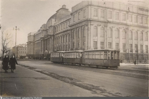
VSEGEI building in the 1960s
During these years, the following were compiled and published: Geological Map of the Urals at 1: 500,000 scale (Editor-in-chief I.I. Gorsky), Metallogenic Map of the Eastern Part of Central Asia at 1:1,000,000 scale (ed. E.D. Karpov), the first Geological Map of the Baikal Mountain Region at 1:500,000 scale (compiled by L.I. Salop et al., ed. T.N. Spizharsky), Map of the Quaternary Deposits of the USSR at 1:5,000,000 scale, first edition (Editor-in-chief G.S. Ganeshin), the first Hydrogeological Map of the USSR at 1:2 500,000 scale (1960) and Hydrochemical Map of the USSR at 1:5,000,000 scale (1963) (Editor-in-chief I.K. Zaitsev), the first Geomorphological Map of the USSR at 1:5,000,000 scale (Editor-in-chief I.I. Krasnov) and finally was published Geological Map of the Baikal Mountain Region at 1:1,500,000 scale, compiled by L.I. Salop, who for the first time in the USSR applied the zonal legend for small-scale maps.
Together with the Palaeontological Institute of the USSR Academy of Sciences, 15 volumes of “Fundamentals of Palaeontology” were compiled and published in 1958-1962. Its editors were awarded the Lenin Prize, including B.P. Markovsky. M.F. Vikulova, in the “Methodological Guide to the Petrographic and Mineralogical Study of Clays” (1957), which was awarded the Stalin Prize, proposed a new methodology for investigating clay minerals, which were still almost unstudied. In 1964, the book “Physical Properties of Rocks and Minerals” was published (edited by G.M. Gapeev and N. B. Dortman), which for the first time formulated the definition of petrophysics as an independent section of geophysics, which is the connecting link between geophysical and geological constructions and which laid the foundation for the widespread use of petrophysics in regional geological investigations, in prospecting and drilling. Fundamental work “Geological and Economic Characteristics of Coal Regions in the USSR” edited by I.I. Gorsky and V.I. Yavorsky was compiled; it contains an assessment of coal regions and their development prospects, data on the forecast substantiation, a program for further prospecting and exploration of deposits.
Fund of promising areas was expanded by polymetallic ores in Central and Southeast Kazakhstan, Central Asia, Altai, Transbaikalia, and the Far East, non-ferrous and rare metals in Kazakhstan, Central Asia and Primorye, mica in Karelia and Mama-Chuya region of Siberia; main directions for further prospecting for diamonds in the Urals and the West Yakutia province with diamondiferous kimberlites and diamond placers were outlined.
Section of Regional Petrography of the Interdepartmental Petrographic Committee (Chairman G.M. Gapeeva) began to work at VSEGEI.
1965 – The first edition of the USSR State Geological Map at 1: 1,000,000 scale was basically completed. It was drawn up sheet-by-sheet according to the international numbering of sheets at 1:1,000,000 scale. VSEGEI employees participated in the compilation of more than half of the sheets of the first edition of Gosgeolkata-1000.
The need to generalize and comprehend the materials obtained from the State Geological Survey at 1:200,000 scale (just done for the USSR), as well as the latest materials from case studies, raised the question of compiling and publishing a new series of Gosgeolkata-1000. The Main Editorial Board of the State Geological Map of the USSR at 1:1,000,000 scale (new series) was created, which consisted mainly of the institute employees. Its chairmen were successively V.A. Bobrov, Yu.S. Zhelubovsky, S.A. Muzylev, G.N. Shaposhnikov.
Monographs “Altai Tectonics” by V.P. Nekhoroshev and “Non-granite pegmatites” by N.M. Uspensky were published. A.I. Semenov was awarded the Lenin Prize for work in the field of uranium geology.
1966 – the first edition of the integral small-scale maps compiled by VSEGEI:
- Tectonic Map of the USSR at 1:5,000,000 scale (Editor-in-chief T.N. Spizharsky);
- Hydrochemical Map of the USSR. Mineral Water. Scale 1:5,000,000 (Editors-in-chief I.K. Zaitsev, N.I. Tolstikhin);
- Geological Map of the Crystalline Basement of the Russian Platform at 1: 2 500,000 scale (Editor-in-chief L.A. Vardanyants).
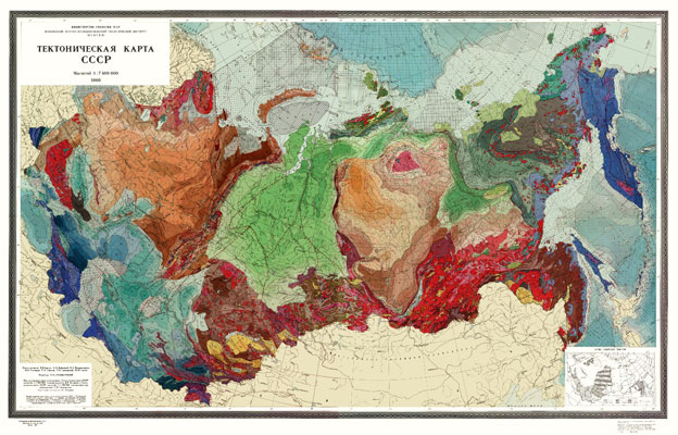
Tectonic map of the USSR, 1966
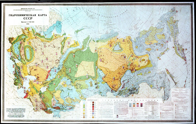
Hydrochemical map of the USSR, 1966
Geological Map of Central Asia and Adjacent Areas at 1: 1,500,000 scale (Editor-in-chief A.P. Markovsky) compiled at VSEGEI was published. According to available data, it showed the position of the Tien Shan and Pamir structures among the geological structures of Central Asia.
The following works were published: monograph "Geology of the Siberian Platform" (edited by I.I. Krasnov, M.L. Lurie, V.L. Masaitis), three-volume monograph “Palaeopalynology”, the last fundamental work created on the initiative and edited by I.M. Pokrovskaya, and capital work by Yu.Ir. Polovinkina “Structures and textures of igneous and metamorphic rocks”, which for many decades remained a reference book of all petrographers.
1967 – Opening of the first memorial plaques with the names of outstanding scientists of GeolCom-VSEGEI. Their contribution to the formation of a powerful raw material base of the country is invaluable. The memory of these scientists is preserved in the names of mountain ranges, islands, bays, glaciers, towns, streets, mines, scientific institutions and schools.
Publication of the two-volume monograph “Geology of the Baikal Mountain Region” by L.I. Salop and monograph “Carbon Formations” by G.A. Ivanov was complete.
In the 60s, VSEGEI, along with compiling separate small-scale overview maps, began to draw up sets (atlases) of maps with different geological content, having the same scale and basis, mutually complementing each other, which helped a comprehensive study of the geology and minerals of the country and individual regions.
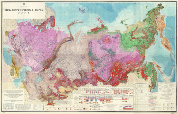
Metallogenic map of the USSR, 1967
The first set covering the USSR was compiled at 1:7,500,000 scale and published in 1967, which later became the VI volume of the monograph “Geological Structure of the USSR”. In 1967-1969, the Atlas of Lithological and Palaeogeographic Maps of the USSR at 1:7,500,000 scale edited by A.P. Vinogradov, V.N. Vereshchagin, A.V. Khabakov et al. was published.
1969 – Publication of the six-volume monograph “Geological Structure of the USSR” was completed (Editor-in-chief E.T. Shatalov, volumes edited by L.I. Borovikov, A.I. Zhamoida, Yu.Ir. Polovinkina, A.I. Semenov, T.N. Spizharsky, A.D. Shcheglov,) with a set of seven geological maps at 1: 7,500,000 scale (geological (edited by D.V. Nalivkin), Quaternary deposits (G.S. Ganeshin), geomorphological (G.S. Ganeshin), tectonic (T.N. Spizharsky), major metallogenic zones (K. B. Ilyin), hydrogeological (I.K. Zaitsev), hydrochemical (I.K. Zaitsev, N.I. Tolstikhin)) was complete.
Publication of the “Instructions for the Compilation and Preparation for Publication of the State Geological Map of the USSR at 1:200,000 scale” prepared by VSEGEI, which was officially valid until 1995 and played a major role in ensuring geological surveying with uniform rules for processing their results and preparing for publication.
1970 – VSEGEI, first in our country, began to study issues of impact metamorphism, geology and minerageny of impact structures (V.L. Masaitis, M.V. Mikhailov, T.V. Selivanovskaya and others).
Publication of the three-volume monograph “Geological Features of Uranium Regions of the USSR” (Research advisor A.I. Semenov) was completed and the monograph “Minerageny of the Siberian Platform” (edited by Yu.G. Staritsky and P.M. Tatarinov) was published.
The first in the USSR Map of Geological Formations of East Kazakhstan at 1:1,500,000 scale was published (edited by L.I. Borovikov, M.A. Aleksandrov), the first in VSEGEI experience in compiling a specialized formation map for an area with complex structure, and the Geological Map of the Russian Platform and its Framing at 1:1 500,000 scale (Editor-in-chief D.V. Nalivkin).
1971 – VSEGEI was honoured with the highest award of the country, the Order of Lenin, for the great successes achieved by the Institute’s team in the geological study of the country, identification of the patterns of mineral deposits distribution, and the increase in the efficiency of geological exploration. Dozens of the institute employees were awarded orders and medals of the USSR, received honorary titles of national and sectoral significance. Veterans of GeolCom- VSEGEI Professors A.P. Markovsky and V.I. Yavorsky became Heroes of Socialist Labour.
Metallogenic map of the USSR at 1:2 500,000 scale was published (resp. ed. G.V. Grushevoy, K. B. Ilyin, G.S. Labazin, V T. Matvienko, A.I. Semenov, P.M. Tatarinov, E.T. Shatalov) and the first Map of Magmatic Formations of the USSR at 1:2 500,000 scale (ed. by D.S. Kharkevich, V.N. Moskalev); “Instruction for the Organization and Conduct of Geological Survey of the Quaternary deposits at 1:200,000 (1:100,000) scale” by S.V. Epshtein were published.
1972-1973 – Four-volume monograph “Geology of North-East Asia” was published (edited by L.I. Krasny, V.N. Vereshchagin, G.S. Ganeshin, S.A. Muzylev, V.K. Putintsev et al.), summing up work results of a large team of VSEGEI employees and local geological departments on a comprehensive analysis of the geological structure, development history, and mineralogy of the East of the USSR.
Monograph was accompanied by a series of eight maps for the first time compiled and published in different years (1966-1977) for the northwestern part of the Pacific mobile belt (within the USSR) at 1:1,500,000 scale (geological, structural formation, exogenic minerageny, endogenic minerageny, forecast metallogenic maps for mercury and antimony, lead and zinc, gold, and a registration map for endogenic minerals).
1974 – Tectonic map of the Russian Platform and its Adjacent Regions at 1: 1,500,000 scale was published (Editor-in-chief T.N. Spizharsky, deputies V.P. Kirikov, for the Urals O.A. Kondiayn), accompanied by explanatory note.
Proposed methodology for compiling a map, with highlighting structural levels in the cover, for the first time made it possible to fully show the sedimentary cover structure of the Russian Platform to its entire depth and to reveal its major formation stages. Subsequently, this technique was widely used in compiling regional tectonic maps and, as a result, became mandatory, enshrined in instructional documents, when compiling sets of sheets of the State Geological Maps at 1:200,000 and 1:1,000,000 scales.
Interdepartmental Lithological Committee was created, the three sections of which worked at VSEGEI: palaeogeography and facies analysis (chairmen A.V. Khabakov, N.N. Predtechensky), nodules and nodule analysis (chairman A.V. Makedonov), sedimentary aluminium, manganese and iron ores (chairman B.M. Mikhailov).
Publication of the three-volume monograph “Geochronology of the USSR” (edited by N.I. Polevaya, Yu.Ir. Polovinkina, V.A. Zubakov) and compilation of the Soviet part of the International Geological Map of Europe at 1:1,500,000 scale (headed by S.A. Muzylev) and the International Metallogenic Map of Europe at 1:2,500,000 scale (headed by E.T. Shatalov) was complete.
D.M. Milshtein was awarded the USSR State Prize for participating in expedited exploration and preparation for exploitation of the unique Shatlyk gas field in Turkmenistan.
1975 - At VSEGEI, the Council to coordinate research and thematic geological and geophysical work in the area of the Baikal-Amur Mainline (chairman L.I. Krasny) was created. Considering the need for a basic geological map, VSEGEI quickly compiled and in 1978 published the Geological Map of the BAM Region at 1:1,500,000 scale (edited by L.I. Krasny).
The first Geological Map of Eurasia was published at 1: 5,000,000 scale (Editor-in-chief A.P. Markovsky). Publication of a number of monographs on: stratigraphy (M.A. Rzhonsnitskaya, A.P. Rotay etc.), coal geology (G.A. Ivanov, N.V. Ivanov, A.A. Lyuber, N.V. Shabarov), tectonics (N.S. Malich), hydrogeology (E.A. Baskov, S.N. Surikov) and guidelines for laboratory research (V.N. Toporsky).
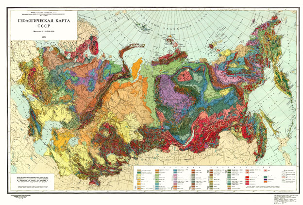
Geological map of the USSR, 1975
1976 – Compilation of the 10-volume monograph “Geological Structure of the USSR and the Laws Governing the Distribution of Mineral Resources” began (Editor-in-chief A.V. Sidorenko, Deputy editor-in-chief A.I. Zhamoida, A.V. Peyve, R.I. Sokolov, A.D. Shcheglov), and publication of the yearbook “Scientific Research Results of VSEGEI” (Resp. ed. S.A. Toporets) transformed in 2002 by the decision of the Academic Council of the Institute into the yearbook “Izvestia VSEGEI” (Editor-in-chief O.V. Petrov, resp. ed. S.A. Toporets).
Map of the Quaternary Deposits of the USSR at 1:2,500,000 scale (edited by G.S. Ganeshin) and the Map of Geological Formations of the Siberian Platform Cover at 1:1,500,000 scale (Editor-in-chief N.S. Malich) were published for the first time.
1977 – The first Map of Magnetic Anomaly Field ΔТа of the USSR (the continental part and some adjacent water areas) at 1:2,500,000 scale (edited by Z.A. Makarova) was published.
With the participation of petrographers from different regions of the country, in 1977-1979, four issues of the tables “Age and Formation Correlation of Igneous Formations of the USSR” were prepared and published (edited by V.N. Vereshchagin, V.L. Masaitis, V.N. Moskaleva and I.P. Nikolskaya), which were later widely used in compiling serial legends to the State Geological Maps at 1:1,000,000 and 1:200,000 scales.
Monographs published: S.I. Romanovsky “Sedimentological Foundations of Lithology” and V.V. Gruza “Metrological Problems of Geology”.
60-70s – VSEGEI employees actively and successfully worked in more than 20 foreign countries. In some of them (in Vietnam, Cuba, and Mongolia), the scientists of the Institute stood at the cradle of the nascent national geological surveys and helped to educate the national cadre of geologists.
At the turn of the 70-80s, the USSR Ministry of Geology decided to draw up sets of sheets of the USSR State Geological Map at 1:50,000 scale (State Geological Map-50) as the main and priority direction for the development of geological surveys in the USSR.
This decision led to the need to create a new “Instructions for the Organization and Production of Geological Surveying and Compilation of the State Geological Map of the USSR at 1:50,000 (1:25,000) scale” and it was compiled at VSEGEI under the direction of A.S. Kumpan with the participation of IMGRE and Aerogeologia. However, the program turned out to be unrealistic due to financial and organizational difficulties and the insufficient capacity of the cartographic enterprises of the USSR Ministry of Geology. At the same time, the scientific and methodological developments of the Institute were used in the transition to the preparation of the second edition of the State Geological Map-200.
1980 – Tectonic Map of the Siberian Platform at 1:1 500,000 scale (Editor-in-chief N.S. Malich) and Map of Faults in the USSR and Neighbouring Countries at 1:2 500,000 scale, compiled by VSEGEI, VNIIGeofizika, VNIIZarubezhgeologiya (Editor-in-chief A.V. Sidorenko, executive editor N.N. Belyaevsky and V.A. Unksov) were published for the first time.
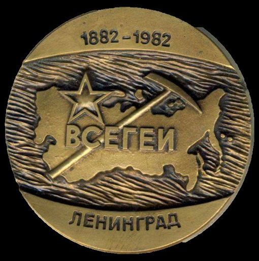
1982 – March 12, by the Decree of the Council of Ministers of the RSFSR, the Institute was named after Academician Alexander Petrovich Karpinsky, Director of GeolCom (1885-1903), Honorary Director of GeolCom (1903-1929), the first elected President of the Russian Academy of Sciences (1917-1925), since 1925, President of the USSR Academy of Sciences.
On April 6-8, the Institute held the 100th anniversary of GeolCom-VSEGEI with a scientific-practical conference and an anniversary session of the Academic Council. Many employees were awarded orders and medals of the USSR, the marks “Honorary Prospector” and “Excellence in prospecting”. The titles “Honorary Veteran of VSEGEI” and “Veteran of VSEGEI”, which marked the Institute’s veteran employees, were first established. Four memorial marble plaques were opened with the names of 48 prominent scientists who worked at GeolCom-VSEGEI.
Publication of the Atlas of Geological and Geophysical Maps of the USSR at 1:10 000,000 scale (Editor-in-chief A.A. Smyslov) incorporating 17 maps and explanatory notes to them was completed. At the Exhibition of Economic Achievements of the USSR, the Atlas was awarded the Diploma of the first degree; 11 employees of the Institute were awarded medals of VDNH.
1984 – “Practical stratigraphy. Development of a Stratigraphic Base for Large-Scale Geological Survey Works” (edited by I.F. Nikitin and A.I. Zhamoida), which is widely used in geological surveying at various scales and as a textbook in universities was published.
1986 – November 6, the official opening of the A.P. Karpinsky’s bust took place on the balustrade of the main VSEGEI building (sculptors V.F. Tikhomolov and O.S. Klyushkin with the participation of architect N.A. Sokolov).

