+7 (812) 328 9282 - Office, +7 (812) 328 9248 - Museum info@karpinskyinstitute.ru
Russian Geological Research Institute (VSEGEI)
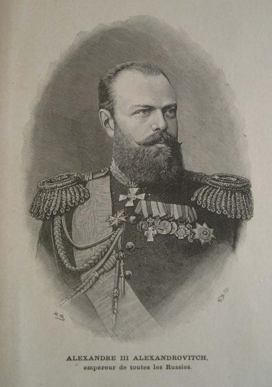
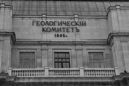
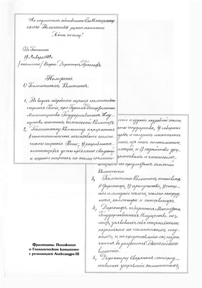
On January 18, 1882, at the suggestion of the State Council, Alexander III approved the Regulation on the Geological Committee and its Staff by a short but clear resolution “So be it”. Thus, the state geological institution of the country was born in Russia, and with it the State Geological Survey, which opened a new era in the development of national geology. These documents were included in the code of laws of the Russian Empire and determined the advanced role of geology in a country rich in mineral resources for many years.
The “Regulations on the Geological Committee” defined a wide range of its main tasks:
New state geological survey was not being formed from nothing. Centralisation in St. Petersburg of the Mining Institute, the Mineralogical Society, and the University was the most favourable condition for the creation of the Geological Committee. During the organization, GeolCom staff consisted of eight people. The first director of the Committee was appointed Academician G.P. Helmersen (1882), a researcher of the European part of Russia, A.P. Karpinsky, I.V. Mushketov, S.N. Nikitin, V.A. Domger, A.A. Krasnopolsky, F.N. Chernyshev, A.O. Mikhalsky were elected members of the Committee. The concentration in GeolCom of talented and dedicated scientists made it possible to find the most rational forms of cooperation with scientists from other departments.
Subsequently, GeolCom was led by V.G. Erofeev (1882-1884), A.P. Karpinsky (1885-1903, Honorary Director in 1903-1929), F.N. Chernyshev (1903-1914), K.I. Bogdanovich (1914-1917).
In December 1882, the first issue of the Proceedings of the Geological Committee was published. The main results of GeolCom activity were regularly published in the Proceedings of the Geological Committee in the form of annual reports.
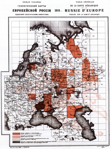
1883-1885 – in April, GeolCom approved the draft “General Plan for the Geological Exploration of Russia”, which provided for a detailed geological survey of European Russia, Donbass, the Urals and other areas. In the shortest possible time 11 sheets (Moscow, Kostroma, Elatma, etc.) of the 10-verst geological map of Russia (A.P. Karpinsky, S.N. Nikitin, F.N. Chernyshev, I.V. Mushketov, N. P. Barbot-de-Marni, A.O. Mikhalsky and others) were compiled.
")
One of the major results of geological survey was the discovery of large deposits: phosphorites in the Kostroma and Yaroslavl provinces (S.N. Nikitin), manganese in the Ukraine (V.A. Domger, Nikopol ore basin), iron, gold, platinum, chromium, rock salt and coal deposits in the Urals (A.P. Karpinsky, F.N. Chernyshev, A.A. Krasnopolsky, etc.).
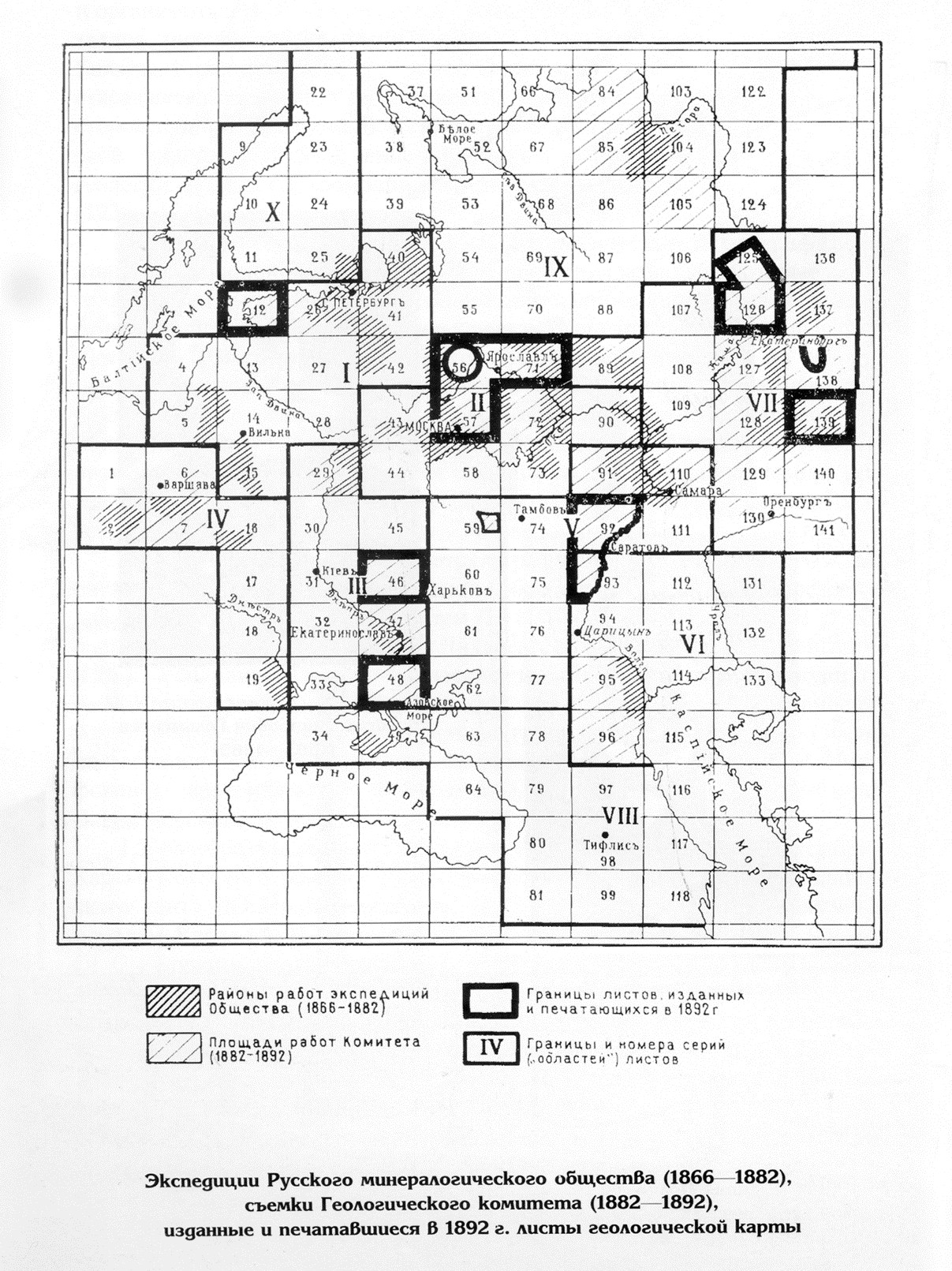
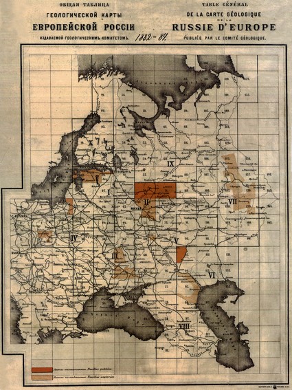
1883 – The Office of the Committee approved the “Instruction to the persons sent by the Geological Committee for systematic research of the geological structure of Russia and compiling its geological map”, compiled by Senior Geologist of the Committee S.N. Nikitin, drawing attention to the “need for complete unity in the general plan” for compiling a geological map of European Russia at 10-verst scale and laying the foundation for systematic geological research in Russia. The proposed surveying technique was tested by the author himself, who worked on sheet 56 (Yaroslavl).
1892 – the Donetsk epic of GeolCom began under the leadership of F.N. Chernyshev. L.I. Lutugin and N.O. Lebedev began to compile a detailed one-verst (1:42 000) geological map. The main performer of this unique project, which later became a classic one, was the founder of national coal geology L.I. Lutugin, appointed as the head of work.
")
GeolCom was involved in geological research along the Trans-Siberian Railway being under construction. The work was carried out by three mountain parties: West Siberian (headed by A.A. Krasnopolsky), Middle Siberian (headed by K.I. Bogdanovich), and Amur (headed by D.L. Ivanov). Route geological maps became the basis for areal study of the regions.
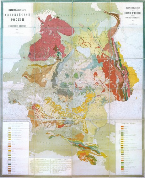
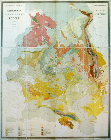
1893 – publication of the first Geological Map of the European part of Russia at 60 versts in an inch scale on 6 sheets with an “Explanatory Brochure” edited by A.P. Karpinsky. The compilers were A.P. Karpinsky (northwestern regions and the Urals), S.N. Nikitin (central regions and the Volga region), F.N. Chernyshev (northern regions and the Urals), I.V. Mushketov (Astrakhan steppes), and I.I. Sorokin and N.P. Barbot-de-Marni (Caucasus and Transcaucasia), A.O. Mikhalsky (Kingdom of Poland), W. Ramzay and J. Sederholm (Finland).
Based on this map, by the sixth IGC Session (1894, Zurich), three sheets of the International Geological Map of Europe at 1:500,000 scale were compiled, taken as a sample. From this moment on, geological small-scale maps of the country compiled by GeolCom-VSEGEI became a crucial document for theoretical and, mainly, practical generalizations and conclusions in the creation of the country's raw material base.
1897 – Russia was granted the right to hold the VII Session of the International Geological Congress (A.P. Karpinsky was elected President of the Congress, and F.N. Chernyshev was elected Secretary General). 704 delegates from 26 countries arrived. The excellent organization of the Session, geological field trips to all areas of European Russia, including the Urals and the Caucasus, the study of modern sediments as part of the Crimean excursion, familiarization with national geological studies made a huge impression. Foreign guests were amazed at Russian hospitality. A year later, GeolCom received a gratitude address with the signatures of all foreign participants in the VII Session. Russia has taken a worthy place among countries with a developed geological survey.
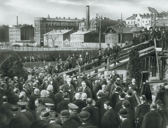
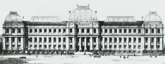
1911 – a decision was made to construct a special building for GeolCom, laid down in 1912 on Sredny Prospect of Vasilievsky Island. By the summer of 1914, the building, aptly named by F.N. Chernyshev the "Palace of Geology", was ready.
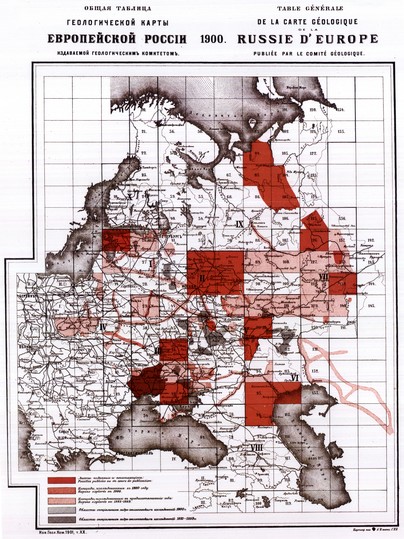
1912 – the program of GeolCom work for 1912-1922 provided to compile a 10-verst geological map for the whole country and to concentrate detailed studies in the most important mining areas. The staff of the committee was increased.
GeolCom began systematic geological research in Central Asia, Altai, and Kazakhstan in the Kalba, Narym, and Tarbagatai ranges (A.V. Nechaev, M.E. Yanishevsky, M.M. Vasilevsky, A.A. Stoyanov). Systematic research began in Siberia (K.I. Bogdanovich, V.N. Zverev, P.A. Kazansky, A.A. Krasnopolsky, A.K. Meister, V.A. Obruchev, A.P. Gerasimov, Ya.S. Edelstein, M.M. Tetyaev, etc.), which made it possible to quickly obtain a general idea of the geological structure of large areas (Baikal, Transbaikalia, Minusinsk Uyezd and the Angara basin, in the North-East, including Chukotka). Geological map of Asian Russia edited by A.K. Meister was compiled and published.
Such a reversal of prospecting, exploration, and evaluation work required staff and financial strengthening of GeolCom. Thanks to the active work of the Committee Director F.N. Chernyshev, the third “Regulation on the Geological Committee” was approved, which increased staffing and funding of work.
World War I made adjustments to the program of work for 1912-1922. Particular attention was paid to the search for strategic raw materials (tungsten, molybdenum, bismuth, tin, etc.).
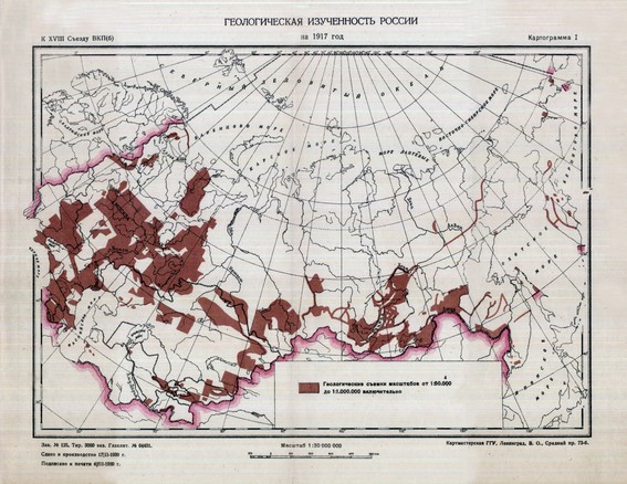
1917 – to its 35th anniversary, GeolCom was formed as the central institution of the state geological survey and at the same time as an integrated research institute. More than two-thirds of European Russia was studied and photographed, including Timan, the Urals, and partially the Caucasus. Kuzbass, the Minusinsk Depressions, the Vitim Uplands, the Amur Region and Primorye, and the north of Sakhalin were investigated east of the Urals. In Central Asia, parts of Turkmenistan, the Karatau and Fergana Ranges were surveyed.
Compilation of 60- and 10-verst geological maps of European Russia, prospecting and exploration in mining areas, discovery of new deposits led to an increase in mineral reserves, revealing the distribution patterns of a number of minerals. GeolCom in practice has shown the effectiveness of systematic geological studies conducted according to a certain plan based on common requirements.
The October Revolution was adopted by GeolCom most likely not as unanimously as the February Revolution. However, a high sense of responsibility for the economic situation in the country, which was always characteristic of GeolCom members, and their desire for planned state organization of work, ensured the continuation of GeolCom activities in the new conditions in Petrograd and in other regions.

